Japanese-American Relocation Camps in Arizona
Home / The Vault / Digital Archives / Japanese-American Relocation Camps in Arizona
Japanese-American Relocation Camps in Arizona
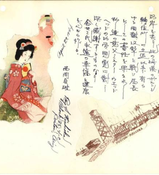
The inspiration for this exhibit came from the discovery of five exquisite watercolors by Kakunen Tsuruoka during a routine inventory of collections. Removed from their deteriorating frames, the fine quality of the artwork was readily apparent. None of the works are titled. One is painted on a fragment of curtain, the others are on paper. They had been presented as a gift to Wade Head, Poston camp Administrator upon his resignation in 1944. Once the watercolors were framed to museum standards, the hunt for the artist and his family was launched. This became an odyssey over many months, leading from one coast to the other. It involved querying national databases, acclaimed experts in Japanese-American camp art, and dead ends too numerous to mention. Finally, contact was made in New York with Ted Tsuruoka, the artist’s grandson, who graciously provided us with biographical information and photographs.
In February 1942, President Franklin D. Roosevelt signed Executive Order No. 9066 that moved 110,000-120,000 Japanese and Japanese Americans into 10 isolated relocation centers in Arizona, Arkansas, California, Colorado, Idaho, Utah, and Wyoming. Among the largest of these were the Poston and Gila River camps in Arizona. While extant, these were two of the largest “cities” in the state. Over 1100 citizens from both camps served in the U.S. Armed Services; of these, 47 died in uniform.
Poston Vital Statistics
- Location: 12 miles south of Parker, Arizona on the Colorado River Reservation
- Opened: May 8, 1942 Closed November 28, 1945
- Size: 71,000 acres
- Climate: Reportedly the hottest of all camps (average temperatures for July and August 1942 unavailable)
- Peak Population: 17,814 (largest relocation camp in the country)
- Origin of prisoners: Southern California, Kern County, Fresno, Monterey Bay Area, Sacramento County, Southern Arizona
- 93.7% answered positively to the U.S. loyalty questionnaire
- Divided into three separate camps – I, II, and III (called Roasten, Toasten, and Dustin by internees)
- Built by Del Webb and 5,000 workers in less than 120 days
- Only camp administered by the Office of Indian Affairs rather than the War Relocation Authority
- From 1942-1945, 662 births and 221 deaths recorded
- Main Industry: Camouflage net factory; warship model building
- Known for its workers strike
Gila River Vital Statistics
Location: 50 miles south of Phoenix, Arizona on the Gila River Indian Reservation
Size: 17,000 acres
Opened: July 20, 1942 Closed: November 10, 1945
- Average temperatures for July and August 1942: 109.6 and 104 degrees
- Peak Population: 13,348
- Origin of prisoners: Sacramento Delta, Fresno County, Los Angeles area
- 90.5% answered positively to the U.S. loyalty questionnaire
- Divided into Canal Camp and Butte Camp
- Main Industry: Largest agricultural program of all the camps. Nearly 1,000 prisoners farmed 8,000 acres of vegetable crops and managed 2,000 head of cattle, 2,500 hogs, 25,000 chickens, and 110 dairy cows
- Only camp visited by Eleanor Roosevelt